Panama's 7.7 Quake Ruptured a Quiet Fault Under the Azuero Peninsula
The worst shaking fell on small towns of the Azuero Peninsula, roughly 160 to 200 km from the capital and the canal. The official toll is low so far, but a USGS loss model and cut-off communities suggest it is provisional.

Tonosí is a town of about 2,300 people near the southern tip of Panama's Azuero Peninsula, 42 km from the epicenter of Friday's earthquake. On Friday, Health Minister Fernando Boyd said it was completely cut off. We are trying to figure out how to get there by air, because it's impossible by land,
he said, according to AFP.
At 12:56 p.m. on Friday, Oct. 9, a magnitude 7.7 earthquake ruptured a fault 12.6 km beneath the peninsula, two blocks of crust lurching sideways past each other, according to the U.S. Geological Survey's event page. In its latest report, issued Friday night and still the most recent as of early Saturday, Oct. 10, Panama's civil protection agency, SINAPROC, reported at least 27 people lightly injured and more than 400 structures affected, with no deaths and no missing people reported and five communities in Los Santos province still cut off.
It may not be over. USGS puts the chance of another magnitude 6 or larger within a week of Friday night at 67%.
Geography explains most of what followed. The hardest shaking fell on a coastal strip of small towns such as Las Tablas, 57 km from the epicenter, and Pedasí. Panama City lies 208 km away. This was a peninsula disaster, watched from a capital that mostly just shook.
Intensity, unlike magnitude, measures what shaking did in a given place. USGS estimates put Tonosí at intensity IX and Macaracas at VIII, while Panama City and Colón, the canal's two ends, came in at about V. Those are modeled figures, but they match where the damage is turning up.
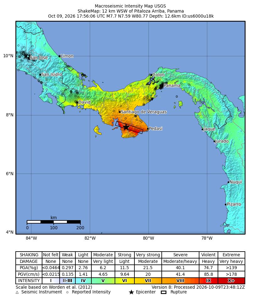
SINAPROC's Omar Smith said damage was concentrated in Veraguas, Herrera and Los Santos. In Penonomé, in Coclé province, one of the cathedral's two towers fell while Bishop Edgardo Cedeño was meeting with several priests, he told EFE; one side of the governor's office collapsed completely. In Soná, Veraguas, most of the fire station collapsed, trapping emergency vehicles and a Zodiac boat, according to SINAPROC's first report. The colonial-style Church of San Atanasio in Los Santos, a National Historic Heritage Site since 1938, collapsed, according to local outlets cited by AP.
SINAPROC's latest tally, carried by EFE, spans nine provinces. Schools are the largest group, with 188 affected, followed by 142 homes. In Los Santos, four hospitals were partially damaged, and about 300 people in a coastal community moved to higher ground as the sea rose. Damaged bridges, broken roads and landslides have isolated five communities there.
In Las Minas, in Herrera province, Ricardo Brown, 74, described life inside his cracked house.
"We're scared. It's just the two of us old folks here. The house has cracked, and we're afraid it could fall on us."
Ricardo Brown, 74, of Las Minas, Herrera province (Reuters)
We are facing a major disaster,
President José Raúl Mulino told reporters, according to AFP.
A fault few people were watching
Panama sits where the Cocos, Nazca, Caribbean and South America plates crowd around a small block called the Panama microplate. USGS says most historical seismicity lies to the west, along the Panama Fracture Zone offshore near Costa Rica. Friday's quake came from somewhere else.
Néstor Luque, director of the University of Panama's Instituto de Geociencias (IGC), attributes it to the Azuero-Soná fault system, which runs northwest to southeast under the peninsula.
"It's a system of active faults that occasionally, due to the accumulation of stress, release this amount of energy."
Néstor Luque, director, Instituto de Geociencias, University of Panama (Reuters)
The seismologists Judith Hubbard and Kyle Bradley, of Earthquake Insights, call that zone "a clear candidate" but say it is "still far too early to know exactly which fault ruptured". USGS describes the motion as left-lateral strike-slip: stand on one side of the fault, and the other side moved to your left.
Citing a 2010 study by Rockwell and colleagues, Earthquake Insights puts sideways slip on the zone at about 5 to 7 mm a year, and adds that "Little work has been done to understand the slip rate, earthquake history, and seismic potential" of faults there. That is what a quiet fault looks like: strain banked a few millimeters at a time, then spent in seconds. The USGS preliminary model has a rupture about 150 km long with up to 7.8 m of slip, more than the length of a family car.
The size is disputed: USGS settled on 7.7 after first reporting 8, while the IGC revised its 7.2 to 7.5. Each 0.2 step roughly doubles the energy, so the gap is about a factor of two.
Why the tsunami warning came and went
About six minutes after the quake, the U.S. National Weather Service began warning Colombia, Ecuador and much of Central America's Pacific coast, based on the first magnitude-8 estimate. About 15 minutes later the magnitude came down, and the warnings were progressively cancelled. Earthquake Insights noted that the USGS model put the rupture "almost entirely under land" and that it moved sideways, which led the seismologists to judge it "unlikely that this earthquake raised a damaging tsunami".
The coast tells a less tidy story. Luque told Telemetro that the Pacific Tsunami Warning Center's model projected waves of 1 to 3 m at Isla Cañas, and that seawater had already entered homes near the coast there. Hubbard and Bradley wrote that the projected 1 to 3 m waves "did not occur". SINAPROC reported increased swell at Isla Cañas. What exactly reached that shore is unsettled.
The Panama Canal kept running. The Panama Canal Authority reported minor damage to four office buildings in its Pacific sector, and damage to steel structures of elevated tanks at the Monte Esperanza water plant in Colón, which kept pumping. Locks and dams remained under technical review, with no impact on transits. Administrator Ilya Espino de Marotta posted on Friday:
The Panama Canal continues normal operations following today’s earthquake. Emergency protocols are in place, and inspections are underway. Safety remains our top priority.
Ilya Marotta (@MarottaIlya) October 9, 2026
Distance protected the canal this time; Earthquake Insights notes that the Pedro Miguel and Limón faults, which cross the waterway, have hosted several quakes of about magnitude 7, found through paleoseismic trenching.
In the capital, Luque counted 40 seconds of vibration, and Reuters described students in uniform pouring into the streets. Tocumen International Airport suspended operations and reopened on Friday afternoon, AP reported, and Naturgy reported power down across six provinces, according to Reuters. The Chilibre water plant serving the capital was reported at 20% capacity by Government Minister Dinoska Montalvo on Friday; by Friday night, IDAAN director Antonio Tercero González said it was back at 100%, with supply recovering gradually.
The count that may still change
Here is the number that does not add up yet. On Friday evening the USGS automated loss model, PAGER, issued an orange alert for fatalities: "Significant casualties are likely." It gave a 1.4% chance of fewer than one death, with its likeliest ranges at 10 to 100 deaths and 100 to 1,000.
PAGER is an automated estimate from modeled shaking, population and building types. Against it stands the official count as of early Saturday: no deaths reported and at least 27 light injuries.
Three explanations exist, none proven. Carlos Valdés, head of the Seismology Department at the National Autonomous University of Mexico, said, according to AP, that Panama's strict building codes, especially for the capital's skyscrapers, may explain the lesser toll; that argument fits best where shaking was weakest. Reuters noted the epicenter lay in a sparsely populated area. The third is the uncomfortable one.
"The maxim 'No news is good news' does not apply to earthquakes: no news tends to instead reflect impacted areas that are less well developed and have fewer or more fragile communication channels to the outside."
Judith Hubbard and Kyle Bradley, seismologists, Earthquake Insights
The injury list leans the way they warn. Coclé, whose capital Penonomé lies 113 km from the epicenter, accounts for 17 of the 27 injured. Los Santos, where USGS modeled the strongest shaking, accounts for six, and five of its communities remain cut off. Mulino cautioned on Friday that the count could change in the coming hours or days. The zero is real as of early Saturday, and provisional until crews reach every village on the peninsula.
Among quakes of magnitude 6.8 or more within 400 km since 1900, Friday's is the largest in the USGS catalog, ahead of the Limón quake in Costa Rica of April 22, 1991. AP describes it as a 7.4 centered in Costa Rica that killed 23 people and left thousands homeless in Panama's border Bocas del Toro region, while USGS PAGER lists it at 7.6 with 75 deaths. Earthquake Insights calls Friday's event "apparently the largest earthquake that has struck on land in Panama in recorded history". An 1882 quake may have been larger, but it struck offshore.
So Panama does get big quakes, mostly offshore and to the west. Its region has had a brutal year: Venezuela's twin quakes in June killed more than 6,500 people, AP reported.
The ground is still moving. The largest aftershock, a magnitude 6.6 by USGS, struck at 3:25 p.m. Friday near Río Grande in Veraguas; the mainshock released about 45 times its energy. A magnitude 6.0 followed at 11:14 p.m. near La Tronosa. This is a mainshock-aftershock sequence, which decays over time, unlike a swarm, but the USGS aftershock forecast keeps the odds high for weeks.
| Window (from Friday night, Oct. 9) | Chance of a magnitude 6 or larger | Chance of a magnitude 7 or larger |
|---|---|---|
| Next day | 39% | 5% |
| Next week | 67% | 12% |
| Next month | 81% | 19% |
| Next year | 92% | 32% |
USGS also expects about 12 aftershocks of magnitude 5 or more in the first week (its 95% range: 3 to 38), and the magnitude 6.0 at 11:14 p.m. Friday already counts toward the first rows.
For Ricardo Brown and his neighbors, the danger is the cracked house. Earthquake Insights warns that large aftershocks can cause damage of their own, especially to buildings already weakened, and authorities say any home with cracks must be evaluated before anyone moves back in. SINAPROC's emergency lines are 520-4426/27 and 911.
Somewhere across Azuero's fields and roads, the fault has almost certainly left a mark. Hubbard and Bradley wrote that a strike-slip quake this large and shallow "is guaranteed to have a significant surface rupture that will be apparent to local residents, and will probably be visible from the air."
The IGC hopes to send seismology and geology teams next week to measure how far the ground was offset, and to study satellite imagery of the break. That scar will be the first hard evidence of what the Azuero-Soná system can do. For a fault Panama had barely studied, the clearest record will come from the day it finally moved.