Derecho or Tornado? The Wind Pattern That Tells You Which
A derecho and a tornado can look equally destructive, but only one of them spins. Here's the wind pattern, and the wind-speed math, that tells them apart.
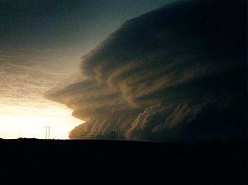
A wall of wind crossed the Midwest at highway speed on Aug. 10, 2020, and in fourteen hours did what most storms take days to manage: it traveled more than 700 miles, gusted as high as 140 mph, and left behind over $11 billion in damage, according to weather-tracking service RainViewer. No funnel cloud ever touched down. There was no rotation anywhere in the storm.
That storm was a derecho, a category of wind event that looks, in radar loops and in the wreckage afterward, uncomfortably close to a tornado outbreak. It gets mistaken for one constantly. The actual difference comes down to a single physical fact: which way the wind is moving.
What actually makes a storm a derecho?
The National Weather Service defines a tornado as "a violently rotating column of air extending from the base of a thunderstorm down to the ground," per restoration company SERVPRO's citation of the agency. A derecho does not rotate. It is a widespread, long-lived windstorm tied to a fast-moving band of thunderstorms, and its winds all travel in the same direction, sometimes for hundreds of miles without a break.
The name gives it away. Derecho is Spanish for "straight ahead" or "direct," picked specifically to separate the phenomenon from a tornado's rotating winds. Most derechos trace back to a bow echo: a curved line of thunderstorms, shaped like an archer's bow on radar, that shoves powerful downdrafts toward the ground. Those downdrafts fan out sideways on impact, and if the line keeps moving fast enough, that sideways fan becomes the storm's whole identity.
Forecasters split them into two patterns. Progressive derechos ride a single fast-moving bow echo, usually in summer, and stay relatively narrow even while covering enormous distances. Serial derechos form inside a larger, more complex storm system tied to a strong low-pressure center: wider, more common in spring and fall, and often arriving with less warning.
How is a derecho different from a tornado, in practice?
Size and duration are the giveaways on the ground. A tornado's damage path is typically no more than a mile wide and the event itself is over in minutes. A derecho's damage path can stretch hundreds of miles across and the wind keeps blowing, in the same direction, for hours. The National Weather Service classifies a storm as a derecho once its wind-damage swath extends more than 240 miles with gusts of at least 58 mph along most of that length. Citing the Storm Prediction Center, SERVPRO describes a stricter version of the same threshold: a damage path stretching more than 400 miles long and 60 miles wide, punctuated by multiple gusts of 75 mph or better.
Storm classification systems rarely map neatly onto what actually threatens a household. The same gap shows up in why a hurricane's category number ignores flood risk, and in how officials escalate danger during fire season, covered in what wildfire preparedness level 5 actually means. A derecho carries no category number at all. It either meets the wind-and-distance criteria or it doesn't.
How fast can derecho winds get?
Fast enough to rival a landfalling hurricane. The August 2020 derecho remains the costliest thunderstorm event in U.S. history. Beyond its $11 billion damage figure, it knocked out power across ten states and flattened enough Iowa cropland that satellite imagery could still trace its path weeks later.
It wasn't the deadliest. In late June 2012, a derecho tore from the Midwest to the Atlantic coast in roughly 12 hours, covering more than 700 miles, cutting power to more than 4 million people and killing at least 22, according to RainViewer's account of the storm. Both storms moved in essentially straight lines the entire way, the signature no tornado outbreak shares no matter how violent.
Forecasters can't say in advance how many derechos will rake the Plains and Midwest before this year's severe weather season winds down, but the setup that produces them (hot, humid surface air colliding with a fast-moving jet stream aloft) is exactly what meteorologists watch for every spring and summer. The next one won't look special on radar at first. It will just keep moving in a straight line, mile after mile, long after a tornado would already have come and gone.