Mexico's $175 Million Hurricane Bond Turns on Where Simon Crosses a Line
Simon's eyewall sits very near Mexico's Pacific coast and forecasters can't say whether it will make landfall. The same few miles of track decide whether a World Bank catastrophe bond pays Mexico anything.
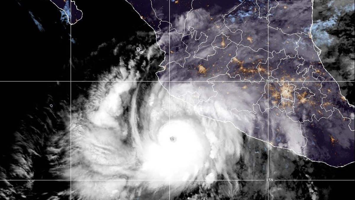
A few miles off the Colima and Jalisco coast runs a boundary that no fishing crew, hotel guest or harbor pilot can see. It exists only in the terms of a bond. As of 3 a.m. CST Sunday, Hurricane Simon's pressure was already below the level that, according to sources cited by the trade publication Artemis, could pay Mexico's government tens of millions of dollars if the storm crosses it.
The forecasters watching the same storm cannot say whether its eye will cross the coastline at all.
At the hurricane center's 3 a.m. advisory on Sunday, Oct. 11, 2026, Simon was a Category 4 hurricane, with 155 mph winds and a central pressure of 930 millibars, its center about 60 miles west-southwest of Manzanillo. That pressure is already below the 932 mb level that, according to sources cited by Artemis, which tracks catastrophe bonds, could trigger a 25% payout, or $43.75 million, from Mexico's $175 million Pacific hurricane bond on the stretch of coast ahead of it.
A millibar is a unit of air pressure, and in a hurricane, lower means stronger. Whether Mexico collects turns on the same few miles of track that decide how hard Puerto Vallarta, Barra de Navidad and Manzanillo get hit.
An eyewall near the coast, and no call on landfall
The National Hurricane Center's Advisory 16 led with a line in capital letters: "EYEWALL OF EXTREMELY DANGEROUS HURRICANE SIMON VERY NEAR THE COAST OF WEST-CENTRAL MEXICO." Simon was crawling north-northwest at 6 mph and, on the forecast track, "is expected to be near or just inland over west-central Mexico later today and move very close to the coast on Monday."
Near is not landfall, as forecaster Blake made clear.
"While some of the models have shifted more offshore later today, it is simply too close to call whether landfall will occur."
National Hurricane Center forecast discussion, 3 a.m. CST Sunday, Oct. 11 (forecaster Blake)
The reason is Simon's size. On Friday evening the center wrote that "A dreaded pinhole eye has formed," and satellite radar had put its radius of maximum winds near 5 nautical miles. Hurricane-force winds reach only 25 miles from the center. A storm that tight can scour one beach town and spare the next, and a wobble of a few miles decides which.
It also grew up fast. Between 0900 UTC Friday and 0900 UTC Saturday, its winds rose from 80 kt to 125 kt, about 50 mph in a single day. "Simon has strengthened incredibly quickly, and that's what makes storms like this so dangerous," AccuWeather meteorologist Dan Pydynowski said, according to Reuters.
Geography pulls on the track too. The center has flagged "a pretty well-known bias that tropical cyclones in this area tend to track east of the forecast track due to interaction with the high topography of coastal Mexico," meaning the Sierra Madre.
"This is a very low confidence forecast," the 3 a.m. discussion said, "because only a small deviation either east or west could result in the hurricane rapidly dissipating after landfall or keeping more strength offshore."
Puerto Vallarta shut down for the night
A hurricane warning covers the coast from Punta San Telmo to El Roblito, which includes Puerto Vallarta, along with Las Islas Marías. A tropical storm watch runs east of Punta San Telmo to Lázaro Cárdenas.
The town-by-town odds from that advisory show how lopsided a small storm's threat is. These are five-day chances of sustained winds of at least 39 mph, at least 58 mph and hurricane force:
- Barra de Navidad: 99%, 44% and 12%
- Puerto Vallarta: 69%, 23% and 4%
- Manzanillo: 99%, 8% and 1%
Puerto Vallarta's chance of hurricane-force wind is about 1 in 25, down from 6% on Saturday morning. Barra de Navidad's is roughly 1 in 8, and its odds of 58 mph winds sit close to a coin flip. Manzanillo, Mexico's largest port, will almost surely feel tropical-storm winds, yet its hurricane-force odds are 1%, a product of that narrow core.
Rain does not share that precision. NHC expects an additional 10 to 20 inches over portions of southwestern Mexico, with isolated totals of 30 inches in Michoacán, Colima and Jalisco through Monday, warning that it "will produce life-threatening flooding and mudslides, especially in areas of steep terrain." That is the danger a category number leaves out, and it arrives either way. Mexico's weather service forecast waves of 6 to 8 meters (about 20 to 26 feet) on the Jalisco and Colima coasts.
Puerto Vallarta, home to nearly 300,000 residents according to Reuters, spent Saturday closing itself up. Stores and hotels boarded their windows under overcast skies and plywood went over mall windows, The Associated Press reported. Ed Currie, a Canadian tourist, told the AP his plan: "Just stay in the hotel and look out the window hopefully." Then: "I just don't know what to expect."
For travelers, the airport question is settled for now. An FAA notice quoted by Out & About Puerto Vallarta marks Licenciado Gustavo Díaz Ordaz International Airport "AP CLSD" from 6:01 p.m. CST Saturday to 8 a.m. CST Monday, Oct. 12. Volaris canceled all its Sunday flights there, Grupo Aeroportuario del Pacífico confirmed, according to Out & About Puerto Vallarta.
The city has 16 designated shelters with room for 3,906 people, the same outlet reported, and Laura Velázquez Alzúa, Mexico's national civil protection coordinator, asked residents of exposed coastal towns to stay indoors from 5 p.m. Saturday, when transit and supermarkets were also to shut. The U.S. Embassy said coastal schools in Jalisco are closed through Tuesday, Oct. 13, and urged visitors to stay out of the water and "Follow directions from local officials." All figures are as of the 3 a.m. advisory, and conditions are changing; NHC's next updates were due at 6 a.m. and 9 a.m. CST.
A line offshore, measured in millibars
The money at stake comes from a $175 million catastrophe bond the World Bank issued in May 2024. It is parametric, meaning it pays on a measured feature of the storm rather than on adjusted losses. It asks one thing: how low was the central pressure when the storm's center crossed a trigger zone?
Those zones are drawn "slightly offshore, not on the coastline," Artemis reported, and different stretches of coast carry different payout factors. Nothing pays above 937 mb. In Simon's box, Artemis's sources say 932 mb or lower "could activate a 25% payout," and 915 mb would be needed for 50%; Artemis believes payouts rise "linearly with declining pressure between those points."
As a pure illustration of that scale, 930 mb at the crossing would mean about $48.9 million, and 928 mb about $54.0 million. But today's reading is not the one that counts. The pressure that matters is the one at the moment of crossing, interpolated from track data the hurricane center finalizes after the storm.
"So it looks set to be a close-call, but too tough to call either way at this stage."
Artemis, reinsurance trade publication, Oct. 10
That is the forecasters' "too close to call" restated in dollars. If Simon skirts the coast without entering the box, it could batter Barra de Navidad and pay nothing.
When the bond does pay, the money comes out of investors' principal. The World Bank passes it to Mexico's government through Munich Re and Agroasemex, a Mexican state-owned insurer. The bond's 22 investors earn compounded SOFR plus a 0.22% funding margin and a 12% risk margin until the bond matures on April 24, 2028. That risk margin alone comes to $21 million a year, the market's price for weekends exactly like this one.
Otis paid. John, Erick and Polo didn't
The bond's short record, from National Hurricane Center and Artemis figures:
| Storm | Date | Any-payout threshold | Pressure near the coast | Bond outcome |
|---|---|---|---|---|
| Otis | Oct. 25, 2023 | 935 mb (earlier $125M bond) | 929 mb at landfall; about 924 mb at the trigger line (early analysis) | $60 million paid (48%) |
| John | Sept. 23, 2024 | 937 mb | 959 mb at landfall (NHC estimate at the time) | Nothing |
| Erick | June 19, 2025 | 937 mb | 939 mb at peak; 950 mb at landfall | Nothing |
| Polo | September 2026 | 937 mb | Low enough at sea, but never crossed a trigger zone; 965 mb at landfall | Nothing |
| Simon | Oct. 11, 2026 | 937 mb (932 mb for 25% in its path) | 930 mb at 3 a.m. CST Sunday; 928 mb overnight | Pending |
Otis is the case that made the bond real. It struck near Acapulco as a Category 5, killing at least 52 people and causing $12–16 billion in damage, the costliest tropical cyclone on record for Mexico. Its $125 million tranche paid $60 million. Mexico's answer was to buy again in May 2024, 40% bigger.
The misses tell the other half. John came ashore at an estimated 959 mb, far too weak. Erick peaked at an estimated 939 mb, "only two millibars above the level needed." Polo's pressure dipped low enough, but "at no time did the centre of the storm cross a parametric trigger zone." Simon now sits 2 mb on the paying side of the 25% mark, the same margin by which Erick fell short of any payout.
Speaking about Erick in June 2025, Florian Steiger, CEO of the cat bond fund manager Icosa Investments, said: "Such an additional default of a Mexican parametric bond in such short order is bound to reignite debate about trigger design, basis risk and whether the market is truly pricing rapid-intensification exposure." (Basis risk is the gap between what a storm does and what the formula pays.) Artemis, writing about Polo, saw it the other way: the bond "has acted as designed in this case."
Both are right, and the scale explains why. Otis's $60 million equaled 0.375% to 0.5% of its damage. Even a full $175 million would cover roughly 1.1% to 1.5% of an Otis-sized loss (a comparison of scale, not a forecast for Simon). Mexico also holds around $575 million of other parametric insurance with lower triggers, which Artemis said may pay before the bond does. The cat bond is the top layer: it pays fast, it pays a sliver, and it pays on geometry, not on grief.
The coast will count Simon's cost in days, in mudslides and torn roofs and cut roads. The bond's verdict waits on data the hurricane center finalizes after the storm, and Otis's final report took 134 days. Long before anyone settles where Simon crossed the line, the families of Barra de Navidad and Puerto Vallarta will know what it took.