Pyrocumulonimbus, Explained: When Wildfires Make Their Own Storms
When a wildfire burns hot enough, it can build a genuine thunderstorm above itself, one that sparks new fires with dry lightning and can loft smoke into the stratosphere for months.
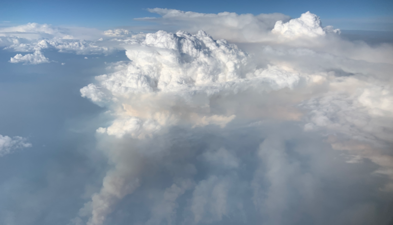
On the afternoon of July 7, a wildfire burning southeast of Lytton, British Columbia, got hot enough to build its own weather. Satellite images from NOAA's GOES-18 spacecraft showed the fire punching a column of smoke and ash into a towering cloud, one intense enough that meteorologists at the University of Wisconsin's Cooperative Institute for Meteorological Satellite Studies flagged it immediately: a pyrocumulonimbus, or pyroCb, the storm cloud a fire builds for itself.
Pyro means fire. Cumulonimbus is the thunderhead that brings lightning, hail and heavy rain. Put them together and you get a genuine, fire-powered thunderstorm — one that can spawn lightning, hurl embers ahead of the flame front, and occasionally spin up a fire tornado, without a drop of the rain landing anywhere near the blaze that made it.
How does a wildfire make its own thunderstorm?
The mechanism starts small. A fire's heat sends a column of hot air rising the way an ordinary thunderstorm's updraft does, carrying smoke, ash and water vapor with it. If the atmosphere above is unstable enough, that plume keeps climbing and cooling, and water vapor condenses onto the ash to form a cloud — first a pyrocumulus, with the telltale brownish, smoke-stained base, then, if the fire keeps feeding it, a full pyrocumulonimbus.
Some of these clouds reach 30,000 to 50,000 feet, high enough to punch through the troposphere into the stratosphere and spread into the same anvil shape as an ordinary severe thunderstorm. That height is exactly why they carry wildfire smoke so far: a plume that size can push ash and aerosols thousands of miles from the fire that produced them.
The Lytton-area fire did precisely that. Five-minute satellite passes tracked cloud-top infrared temperatures in the −40s and −50s Celsius — cold enough, meteorologist Scott Bachmeier noted on the CIMSS Satellite Blog, to confirm ice had formed at the cloud tops. By early the next morning, one drifting fragment of the storm registered a cloud-top temperature of −56.57 Celsius, and smoke from the fire had cut surface visibility at nearby Kamloops airport to three-quarters of a mile.
Why is a pyroCb more dangerous than the fire itself?
Ordinary thunderstorm lightning comes with rain that can help douse what it ignites. PyroCb lightning often doesn't. Because the storm has usually drifted downwind of the fire by the time it's mature enough to produce lightning, any rain that falls lands away from the blaze — while the lightning itself can spark new fires well outside the original perimeter, a phenomenon officials treat as a separate hazard tier from ordinary fire spread. The winds a pyroCb generates can also fan the flames it left behind and, in the worst cases, twist into a fire tornado.
That risk isn't theoretical. In 2018, California's Carr Fire spawned a fire tornado — also called a firenado or fire whirl — that killed a firefighter, a case widely documented at the time by local news crews who captured the funnel on camera as it tore through the burn area.
The clouds also leave a mark long after the fire is out. A 2023 NOAA study found that smoke lofted into the stratosphere by pyroCbs can linger for months: a 2017 fire season in the Pacific Northwest injected so much smoke into the upper atmosphere that remote-sensing instruments worldwide tracked the plume for more than eight months, cooling the surface slightly as it circulated. "These fire clouds are growing larger and more frequent," NOAA scientist Joshua Schwarz said of the finding, while lead author Joe Katich noted the smoke "stick[s] around longer than we thought," with implications reaching beyond wildfire science into how researchers model deliberate atmospheric cooling proposals.
None of that makes a pyroCb easy to forecast. A 2026 study that trained machine-learning models on satellite fire data and weather observations found the models could flag likely pyroCb events with real skill — but unusual fires, the kind that build the most extreme storms, remained the hardest to predict. For firefighters on the ground, the practical takeaway is blunter than any model: once a fire starts building its own thunderhead, it has entered a different category of danger, one where the smoke plume above the flames is telling you more than the fire line below it. Daybreak Wire has tracked a related summer hazard in how wildfires get named under NWS and interagency rules, a system built around the same reality — that a fire large enough to need its own identity is usually large enough to make its own weather, too.