NOAA Declares El Niño and Puts 63% Odds on a 'Very Strong' Event
The Pacific has flipped into its warm phase, and the agency’s new measuring stick says this one could be big. Here is what an El Niño winter usually brings.
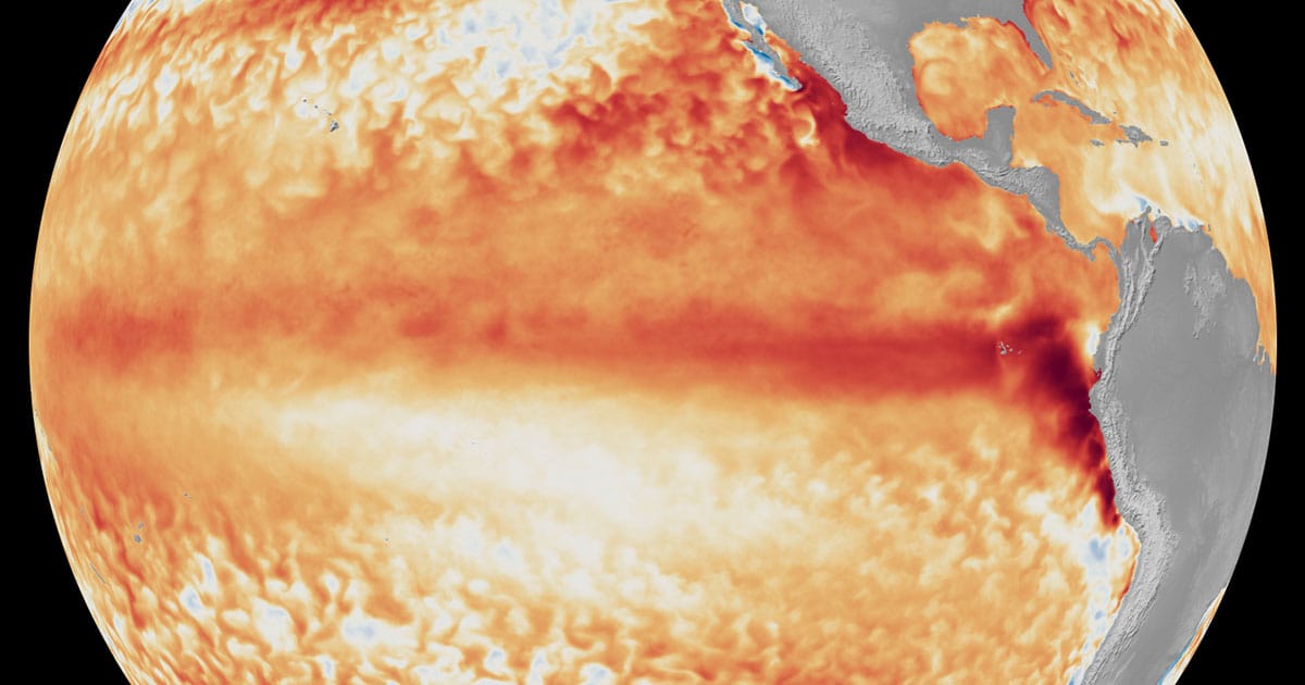
El Niño is back. NOAA's National Weather Service declared on Thursday, June 11 that the climate pattern's warm phase has developed in the tropical Pacific, issuing an official El Niño Advisory and predicting the event will strengthen to moderate or strong intensity this fall.
The forecast carries an unusually assertive number. NOAA forecasters give a 63% chance that sea surface temperatures in the Niño-monitoring region of the Pacific will exceed 2.0°C above average; past that threshold, the agency classifies an El Niño as "very strong." The warming is expected to peak this winter, when the pattern's global effects are usually at their height.
How an El Niño gets declared
The declaration is not a judgment call. NOAA declares an El Niño once temperatures in the equatorial Pacific have run 0.5°C above average for several consecutive months. Forecasters also watch the atmosphere overhead for the breakdown of the Walker Circulation, a massive east-to-west air flow driven by the temperature and pressure differences between the warm western Pacific and the cooler eastern side. When that circulation falters and warm water shifts east toward South America, the event is on.
Both boxes are now ticked, the agency said. Satellite imagery from the first week of June showed the telltale tongue of above-average warmth stretched along the equator.
"Every El Niño is not the same; each one is unique with its own imprint on our weather. Advanced monitoring and an improved understanding of El Niño patterns allow the NWS to better predict and better prepare the public and our core partners for what is to come."
Ken Graham, director of NOAA's National Weather Service
What a typical El Niño winter brings
El Niño matters most to the United States in winter. The jet stream over the North Pacific tends to shift southward, dragging the storm track across the southern tier of the country and raising the chances of both rain and snow there. The same shift leaves the Northern Rockies and the Ohio and Tennessee valleys drier than usual, while the northern U.S. often runs warmer than normal.
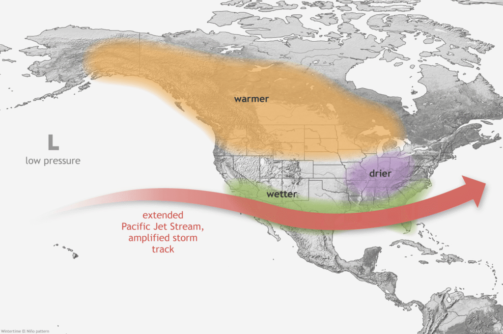
Beyond the storm track, NOAA lists a familiar set of knock-on effects:
- Stronger upper-level winds that tend to suppress storm and hurricane development in the Atlantic basin, while weaker winds favor tropical development in the eastern and central Pacific. NOAA has already predicted a below-normal 2026 Atlantic hurricane season.
- A higher risk of high-tide flooding in parts of the U.S., especially on the West Coast.
- Shifts in fish migration, with warm-water species moving north and cold-water species pushed farther north or into deeper water, with consequences for growth, survival and reproduction.
- A history of enhanced harmful algal blooms along the West Coast during past El Niño episodes.
A new ruler for an old pattern
This advisory is the first El Niño declaration to arrive under a new measuring system. In February, NOAA officially adopted the Relative Oceanic Niño Index, or RONI, for monitoring sea surface temperatures and forecasting El Niño and La Niña. The traditional Oceanic Niño Index compares ocean temperatures against a static 30-year baseline; RONI's baseline evolves from month to month, which NOAA says makes the index more reliable for identifying events.
The agency's ENSO team had tracked both yardsticks side by side since 2021 and concluded that RONI correlated more closely with the expected changes in the Walker Circulation, the atmospheric half of the phenomenon, and so gave weather experts, emergency managers and the public more useful information.
NOAA reissues its ENSO diagnostic discussion every month, and each one will tighten the strength forecast through summer and fall. Cross 2.0°C and the 2026-27 winter opens under a very strong El Niño, the southern storm track loaded and the hurricane-suppressing winds locked in. The pattern has declared itself. What it does with the months it has left is the part no index can call yet.


