Texas faces days of flooding as a Gulf system may become Arthur
The system may or may not earn a name. The flooding threat from the Texas coast into the Deep South is already here, the hurricane center says.
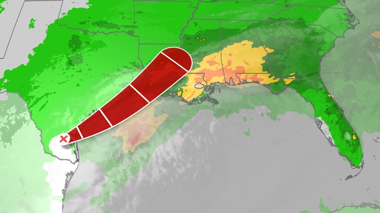
The first tropical system of the 2026 Atlantic season is taking shape off the Texas coast, but the danger forecasters keep stressing is not the wind, or the name it might earn. It is the rain.
The National Hurricane Center on Tuesday designated the disturbance Potential Tropical Cyclone One and warned that, whether or not it strengthens into Tropical Storm Arthur, heavy rainfall and life-threatening flash flooding will be the main threat from the Texas coast eastward into Mississippi through Thursday.
"The main hazard with these types of systems is largely the flooding from the heavy rainfall. And we could see potentially life-threatening flash and urban flooding across the Texas coast eastward into central Mississippi through Thursday. Prolonged rainfall may extend the flood threat into the weekend."
Michael Brennan, director of the National Hurricane Center
The setup is already producing what it threatens. On Monday, 2 to 5 inches of rain triggered flash flooding across central, southern and eastern Texas into Louisiana and southern Mississippi; in Burleson County, Texas, five vehicles were stranded in high water and had to be reached by rescuers. Through Saturday, some areas could pick up another 5 to 12 inches, with higher local totals where bands of rain stall.
The reason is geometry as much as strength. Forecasters expect the system to hug the coast and drift offshore for roughly a day on Wednesday before pushing back inland late Wednesday or Thursday, a slow track that lets the same warm, soaked Gulf air train over the same counties for hours. A storm does not need a name or a tight eye to drop a foot of water. It needs time, and this one has it.
A tropical storm watch covers the coast from Sargent to Sabine Pass, Texas, and a tropical storm warning runs from Sabine Pass east to Morgan City, Louisiana, where sustained winds could reach 39 mph or more. Storm surge of 2 to 4 feet is possible from Port Bolivar, Texas, to Morgan City, and flood watches reach inland to take in Corpus Christi, Houston and New Orleans. An isolated tornado cannot be ruled out along the coast.
Texas was already braced. Governor Greg Abbott this week declared a disaster in 101 counties ahead of the flood threat, a measure of how raw the state's nerves are after recent water emergencies.
Whether the system tightens enough to claim the name Arthur, the first on the 2026 list, may be settled in a matter of hours offshore. For the people under the flood watches it is close to irrelevant. The advice from the hurricane center and local forecasters is the unglamorous kind that saves lives in a Gulf June: watch for flash-flood warnings, and never drive onto a flooded road. Turn around instead.


